 Catálogo IDEAndalucia
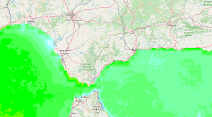
REDIAM. WMS Serie de imágenes de satélite NOAA-AVHRR. SST (Sea Surface Temperature) anomalía anual: Año 2013 serie histórica 2000-2013. 1100 m
Servicio WMS de la Imagen de satélite NOAA-AVHRR anomalía anual de SST (Sea Surface Temperature) del año 2013 respecto a la media del periodo 2000-2013. Resolución espacial 1100 m. Ámbito Océano Atlántico y Mar de Alborán. En ETRS89 UTM huso 30. Con el propósito de Obtener los cambios de la temperatura superficial del mar del último año de estudio, respecto a su comportamiento medio a lo largo de la serie histórica 2000-2013. Con esta imagen, se puede observar el aumento o disminución de este parámetro geofísico, que influye en la transferencia del vapor de agua y de los gases entre el océano y la atmósfera, lo que a su vez es condicionante del clima, siendo también representativo de los principales cambios que pueden ocurrir en el medio marino. Consejería de Medio Ambiente y Ordenación del Territorio. Junta de Andalucía. Nodo de la Red de Información Ambiental de Andalucía. Junta de Andalucía. Integrado en la Infraestructura de Datos Espaciales de Andalucía, siguiendo las directrices del Sistema Cartográfico de Andalucía.
Simple
- Date (Revision)
- 2020-08-31T10:32:32
- Status
- Completed
- Point of contact
-
Organisation name Individual name Electronic mail address Role Consejería de Medio Ambiente y Ordenación del Territorio. Junta de Andalucía
--
Point of contact
- Theme
-
-
WMS
-
Andalucía
-
REDIAM
-
sensor
-
satélite de observación
-
teledetección
-
temperatura
-
Océano Atlántico Norte
-
Océano Atlántico Sur
-
océanos
-
mares
-
IDEAndalucia
-
humanInteractionService
-
-
GEMET - INSPIRE themes, version 1.0
-
-
Ortoimágenes
-
-
Registro de temas REDIAM
-
-
Teledetección y caracterización del territorio
-
- Use limitation
-
Para saber la licencia hay que mirar el campo de acceso y uso.
- Access constraints
- Other restrictions
- Use constraints
- Other restrictions
- Other constraints
-
Este servicio se puede usar de modo libre y gratuito siempre que se mencione a los autores y propietarios de la información
- Service Type
- OGC:WMS
- Service Version
-
1.3.0
))
- Coupling Type
- Tight
- Contains Operations
- Distribution format
-
Name Version
- OnLine resource
-
Protocol Linkage Name OGC:WMS-1.3.0-http-get-map
http://www.juntadeandalucia.es/medioambiente/mapwms/REDIAM_noaa_avhrr_sst_anual_filtrada_anomal_2000_2013?
- Hierarchy level
- Service
Attributes
Conformance result
- Date (Publication)
- 2010-12-08
Citation identifier
- Explanation
-
Consultar el reglamento mencionado
- Pass
- Yes
Metadata
- File identifier
- f227abf3ec4b183d2cebfc63fddccb4a8c7aeea4 XML
- Metadata language
- Spanish; Castilian
- Character set
- UTF8
- Hierarchy level
- Service
- Date stamp
- 2022-09-01T10:40:02
- Metadata standard name
-
ISO 19119/2005
- Metadata standard version
-
1.0
- Metadata author
-
Organisation name Individual name Electronic mail address Role Consejería de Sostenibilidad, Medio Ambiente y Economía Azul. Junta de Andalucía
--
Point of contact
Overviews
Spatial extent
Provided by
