 Catálogo IDEAndalucia
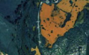
Ortofotografía Río Guadiamar (vuelo Escala 1:20000), Enero 1999
Ortofoto a partir del vuelo fotogramétrico analógico y película fotográfica en COLOR del ámbito del Río Guadiamar perteneciente a las provincias de Sevilla-Huelva, escala de vuelo 1:20.000 del año 1999. Digitalización (Escaneado) de fotogramas del vuelo a 15 micras. La resolución de la ortofoto resultante es de 0.90m. (V118_of).
Simple
- Date (Creation)
- 1999-01-01
- Citation identifier
- Sin identificador
- Presentation form
- Digital document
- Purpose
-
Disponibilidad de Bases Cartográficas de Referencia de ámbito local en la Comunidad Autónoma de Andalucía.
- Status
- Historical archive
- Point of contact
-
Organisation name Individual name Electronic mail address Role Consejería de Medio Ambiente y Ordenación del Territorio. Junta de Andalucía
Author
- Theme
-
-
Fotografía aérea
-
Fotogrametría
-
Vuelo de bajo nivel
-
Opendata
-
IDEAndalucia
-
-
GEMET - INSPIRE themes, version 1.0
-
-
Ortoimágenes
-
- Access constraints
- Other restrictions
- Use constraints
- Other restrictions
- Other constraints
-
Creative Commons Attribution 4.0 International Public License (CC BY 4.0)
- Spatial representation type
- Grid
- Language
- Spanish; Castilian
- Character set
- UTF8
- Topic category
-
- Imagery base maps earth cover
- Location
))
- Supplemental Information
-
01020102
- Reference system identifier
- EPSG: 25830
- Reference system identifier
- INSPIRE RS registry / http://www.opengis.net/def/crs/EPSG/0/25830
- Distribution format
-
Name Version JPEG2000
- Units of distribution
-
Datos en descarga
- OnLine resource
-
Protocol Linkage Name WWW:LINK-1.0-http--related
http://descargasrediam.cica.es/repo/s/RUR?path=%2F01_CARACTERIZACION_TERRITORIO%2F02_BASES_REF_ORTOFOTOS_ORTOIMAGENES%2F01_ORTOFOTOS%2F02_PROYECTOS_LOCALES%2F1999_01_XX_SE-HU_Guadiamar_0.90m_V118_of Descarga Ortofotografía Río Guadiamar (vuelo Escala 1:20000), Enero 1999 (1999_01_XX_SE-HU_Guadiamar_0.90m_V118_of)
- Hierarchy level
- Series
Conformance result
- Date (Publication)
- 2010-12-08
Citation identifier
- Explanation
-
Consultar el reglamento mencionado
- Pass
- Yes
- Statement
-
Para generar la ortofotografía se utiliza la información proporcionada por el vuelo fotogramétrico, el apoyo de campo, la aerotriangulación y el modelo digital de elevaciones.
- Description
-
Vuelo fotogramétrico analógico a partir de la escala 1:20.000 del año 1999 en Color de la Consejería de Medio Ambiente.
Metadata
- File identifier
- 77f9dd0a-1fbd-400e-b32c-d472ef2c0816 XML
- Metadata language
- Spanish; Castilian
- Character set
- UTF8
- Hierarchy level
- Dataset
- Date stamp
- 2022-10-17T09:52:33Z
- Metadata standard name
-
ISO 19115 "NEM"
- Metadata standard version
-
2003 "1.0"
- Metadata author
-
Organisation name Individual name Electronic mail address Role Consejería de Sostenibilidad, Medio Ambiente y Economía Azul. Junta de Andalucía.
Author
Overviews
Spatial extent
Provided by
