 Catálogo IDEAndalucia
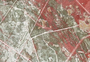
Ortofotografía Incendio de Las Peñuelas (Huelva), 2018
Ortofotografía del ámbito del incendio de Las Peñuelas (Huelva) de 0.25m de resolución y 4 bandas espectrales (rojo, verde, azul, infrarrojo) generada a partir de Vuelo Fotogramétrico-LiDAR de 2018. (V216_of).
Simple
- Date (Creation)
- 2018-08-09
- Presentation form
- Digital image
- Purpose
-
Análisis de la regeneración de la vegetación tras el incendio.
Disponibilidad de Bases Cartográficas de Referencia de ámbito local en la Comunidad Autónoma de Andalucía.
- Status
- Completed
- Point of contact
-
Organisation name Individual name Electronic mail address Role Consejería de Medio Ambiente y Ordenación del Territorio. Junta de Andalucía
Owner
-
Observación del Territorio
-
-
Observación del Territorio. Producto primario
-
-
Registro de temas REDIAM
-
-
Incendios forestales
-
- Theme
-
-
Fotografía aérea
-
Fotogrametría
-
Vuelo de bajo nivel
-
IDEAndalucia
-
Opendata
-
LiDAR
-
Ortofotografía
-
-
GEMET - INSPIRE themes, version 1.0
-
-
Ortoimágenes
-
- Access constraints
- Other restrictions
- Use constraints
- Other restrictions
- Other constraints
-
Creative Commons Attribution 4.0 International Public License (CC BY 4.0)
- Spatial representation type
- Grid
- Distance
- 0.25 m
- Language
- Spanish; Castilian
- Character set
- UTF8
- Topic category
-
- Imagery base maps earth cover
))
Vertical extent
- Supplemental Information
-
01020102
- Reference system identifier
- EPSG:25830
- Reference system identifier
- INSPIRE RS registry / http://www.opengis.net/def/crs/EPSG/0/4258
- Transformation parameter availability
- No
- Checkpoint Availability
- No
- Point in Pixel
-
- Distribution format
-
Name Version JPEG2000
- Units of distribution
-
Datos en descarga
- OnLine resource
-
Protocol Linkage Name WWW:LINK-1.0-http--related
http://descargasrediam.cica.es/repo/s/RUR?path=%2F01_CARACTERIZACION_TERRITORIO%2F02_BASES_REF_ORTOFOTOS_ORTOIMAGENES%2F01_ORTOFOTOS%2F02_PROYECTOS_LOCALES%2F2018_08_09_HU_Penuelas_V216_of Descarga Ortofotografía incendio de las Peñuelas (Huelva), 2018 (2018_08_09_HU_Penuelas_V216_of)
- Units of distribution
-
Servicio WMS
- OnLine resource
-
Protocol Linkage Name OGC:WMS
http://www.juntadeandalucia.es/medioambiente/mapwms/REDIAM_ortofoto_incendio_penuelas_2018? REDIAM. WMS Ortofoto del ámbito del incendio de Las Peñuelas (RGBIr) 2018
- Hierarchy level
- Dataset
Conformance result
- Date (Publication)
- 2010-12-08
Citation identifier
- Explanation
-
Consultar el reglamento mencionado
- Pass
- Yes
- Statement
-
Para generar la ortofotografía se utiliza la información proporcionada por el vuelo fotogramétrico, el apoyo de campo, la aerotriangulación y el modelo digital de elevaciones.
- Description
-
Vuelo Fotogramétrico Lidar del año 2008 de la Consejería de Medio Ambiente.
Metadata
- File identifier
- 42aeea75-ac06-4f60-a736-4f321d95fd6b XML
- Metadata language
- Spanish; Castilian
- Character set
- UTF8
- Hierarchy level
- Dataset
- Date stamp
- 2022-09-01T12:02:16
- Metadata standard name
-
ISO 19115 "NEM"
- Metadata standard version
-
2003 "1.0"
- Metadata author
-
Organisation name Individual name Electronic mail address Role Consejería de Sostenibilidad y Medio Ambiente. Junta de Andalucía
Author
Overviews
Spatial extent
Provided by
