 Catálogo IDEAndalucia
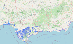
REDIAM. WMS Recopilación de zonas inundables en cauces de Andalucía (T500)
Servicio WMS correspondiente a la recopilación de la delimitación de las zonas inundables para un periodo de retorno de 500 años de los cauces estudiados hasta 2017 por la Administración Hidráulica de la Junta de Andalucía y por la aportada por otras Administraciones. La capa incluye estudios desde 2007, con el E. H. del Litoral Occidental de Huelva, hasta el 2017 con el E.H. para la Delimitación de las Zonas Inundables del Río Guadarranque a su paso por la Estación Férrea. Nodo de la Red de Información Ambiental de Andalucía. Junta de Andalucía. Nodo de la Red de Información Ambiental de Andalucía. Junta de Andalucía. Integrado en la Infraestructura de Datos Espaciales de Andalucía, siguiendo las directrices del Sistema Cartográfico de Andalucía.
Simple
- Date (Revision)
- 2017-12-31T00:00:00
- Status
- Historical archive
- Point of contact
-
Organisation name Individual name Electronic mail address Role Consejería de Sostenibilidad y Medio Ambiente. Junta de Andalucía
--
Point of contact
-
Registro de temas REDIAM
-
-
Litoral
-
-
ISO
-
-
infoMapAccessService
-
IDEAndalucia
-
- Theme
-
-
WMS
-
Andalucía
-
REDIAM
-
agua
-
hidraúlica
-
hidrología
-
inundaciones
-
crecidas
-
-
GEMET - INSPIRE themes, version 1.0
-
-
Zonas de riesgos naturales
-
-
Registro de temas REDIAM
-
-
Agua
-
- Use limitation
-
Para saber la licencia hay que mirar el campo de acceso y uso.
- Access constraints
- Other restrictions
- Use constraints
- Other restrictions
- Other constraints
-
Este servicio se puede usar de modo libre y gratuito siempre que se mencione a los autores y propietarios de la información
- Service Type
- OGC:WMS
- Service Version
-
1.3.0
- Fees
-
Gratuito
))
- Coupling Type
- Tight
- Contains Operations
- Distribution format
-
Name Version WMS
1.3.0
- Units of distribution
-
Servicio WMS
- OnLine resource
-
Protocol Linkage Name OGC:WMS-1.3.0-http-get-map
http://www.juntadeandalucia.es/medioambiente/mapwms/REDIAM_zonas_inundables_Andalucia? REDIAM. WMS Recopilación de zonas inundables en cauces de Andalucía (T500)
- Units of distribution
-
Ficha WMS
- OnLine resource
-
Protocol Linkage Name WWW:LINK-1.0-http--link
https://www.juntadeandalucia.es/medioambiente/portal/landing-page-servicio-ogc/-/asset_publisher/1qlWV3LW9vV6/content/rediam.-wms-zonas-inundables-de-andaluc-c3-ada/20151 Ficha WMS Recopilación de zonas inundables en cauces de Andalucía (T500)
- Hierarchy level
- Service
Attributes
Conformance result
- Date (Publication)
- 2010-12-08
Citation identifier
- Explanation
-
Consultar el reglamento mencionado
- Pass
- Yes
Metadata
- File identifier
- 36a97f0a16c4f49aa9f1cbe39476f097ad2f8cc7 XML
- Metadata language
- Spanish; Castilian
- Character set
- UTF8
- Parent identifier
-
Recopilación de zonas inundables para un periodo de retorno de 500 años procedentes de estudios hidrológicos en cauces concretos de Andalucía
dffaed9a-3699-4c02-aa6d-e3907d07c13a
- Hierarchy level
- Service
- Date stamp
- 2024-11-25T18:03:39.122Z
- Metadata standard name
-
ISO 19119/2005
- Metadata standard version
-
1.0
- Metadata author
-
Organisation name Individual name Electronic mail address Role Consejería de Sostenibilidad y Medio Ambiente. Junta de Andalucía
--
Point of contact
Overviews
Spatial extent
Provided by
