 Catálogo IDEAndalucia
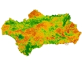
Índice de Vegetación (NDVI) de Andalucía. Promedio mensual, 2014 (TERRA MODIS)
Imágenes del satélite TERRA captadas por el sensor MODIS (Moderate-Resolution Imaging Spectroradiometer) a las que se les ha calculado el Índice de Vegetación de la Diferencia Normalizada (NDVI- Normalized Difference Vegetation Index), que basado en el contraste entre las bandas roja e infrarroja cercana del espectro, resalta la cobertura vegetal y su vigorosidad sobre áreas extensas. Las imágenes presentan una sola banda y una resolución espacial de 250 m.
Simple
- Date (Creation)
- 2011-01-03
- Date (Publication)
- 2011-01-03
- Citation identifier
- Sin identificador
- Presentation form
- Digital image
- Status
- Completed
- Point of contact
-
Organisation name Individual name Electronic mail address Role Consejería de Medio Ambiente y Ordenación del Territorio. Junta de Andalucía
Author
-
Registro de temas REDIAM
-
-
Biodiversidad y Vegetación
-
- Theme
-
-
Imagen vía satélite
-
Sensor
-
Satélite de observación
-
Teledetección
-
Tratamiento de imágenes
-
IDEAndalucia
-
-
GEMET - INSPIRE themes, version 1.0
-
-
Ortoimágenes
-
- Use limitation
-
Derechos de propiedad intelectual.
- Access constraints
- Intellectual property rights
- Use constraints
- Intellectual property rights
- Other constraints
-
Dirigido al público en general. "Original Data distributed by the Land Processes Distributed Active Archive Center (LP DAAC), located at the U.S. Geological Survey (USGS) Earth Resources Observation and Science (EROS) Center (lpdaac.usgs.gov)."
- Spatial representation type
- Grid
- Language
- Spanish; Castilian
- Character set
- UTF8
- Topic category
-
- Environment
- Imagery base maps earth cover
))
- Supplemental Information
-
040101010402
- Reference system identifier
- EPSG:25830
- Reference system identifier
- INSPIRE RS registry / http://www.opengis.net/def/crs/EPSG/0/4258
- Distribution format
-
Name Version Tif
- Units of distribution
-
Servicio WMS
- OnLine resource
-
Protocol Linkage Name OGC:WMS-1.3.0-http-get-map
http://www.juntadeandalucia.es/medioambiente/mapwms/REDIAM_terra_modis_ndvi_mensual_2014? WMS Serie de imágenes de satélite TERRA MODIS. NDVI (Normaliced Difference Vegetation Index) medias mensuales. 250 m. Año 2014
- Units of distribution
-
Ficha WMS
- OnLine resource
-
Protocol Linkage Name WWW:LINK-1.0-http--related
http://www.juntadeandalucia.es/medioambiente/site/rediam/menuitem.04dc44281e5d53cf8ca78ca731525ea0/?vgnextoid=1bda8c533c1de410VgnVCM1000001325e50aRCRD&vgnextchannel=07b859e829165310VgnVCM2000000624e50aRCRD&vgnextfmt=rediam&lr=lang_es Ficha WMS Serie de imágenes de satélite TERRA MODIS. NDVI (Normaliced Difference Vegetation Index) medias mensuales. 250 m. Año 2014
- Units of distribution
-
Kml
- OnLine resource
-
Protocol Linkage Name WWW:LINK-1.0-http--related
http://www.juntadeandalucia.es/medioambiente/portal_web/rediam/productos/ServiciosOGC/KML/Cartografia_ambiental/Biodiversidad/2014_terra_modis_med_men_ndvi.kml 2014_terra_modis_med_men_ndvi.kml
- Units of distribution
-
Aplicación Web
- OnLine resource
-
Protocol Linkage Name WWW:LINK-1.0-http--related
https://laboratoriorediam.cica.es/VisorIndicesVegetacion/?hlayer=true Visualizador para el seguimiento del estado de la vegetación en Andalucía
- Units of distribution
-
Publicación web
- OnLine resource
-
Protocol Linkage Name WWW:LINK-1.0-http--related
http://www.juntadeandalucia.es/medioambiente/site/rediam/menuitem.f361184aaadba3cf8ca78ca731525ea0/?vgnextoid=7bba03d78270f210VgnVCM2000000624e50aRCRD&lr=lang_es Seguimiento del estado de la vegetación
- Units of distribution
-
Datos en descarga
- OnLine resource
-
Protocol Linkage Name WWW:LINK-1.0-http--related
http://descargasrediam.cica.es/repo/s/RUR?path=%2F04_RECURSOS_NATURALES%2F01_BIODIVERSIDAD%2F01_VEGETACION_ECOSISTEMAS%2F01_VEGETACION_NATURAL%2F04_INDICE_SATELITE%2F02_TERRA_MODIS%2F2014TERMODMEDMNDVI Descarga Índice de Vegetación (NDVI) de Andalucía. Promedio mensual, 2014 (TERRA MODIS) (2014TERMODMEDMNDVI)
- Hierarchy level
- Series
Conformance result
- Date (Publication)
- 2010-12-08
Citation identifier
- Explanation
-
Consultar el reglamento mencionado
- Pass
- Yes
- Statement
-
Cambio de formato, reproyección de las imágenes y cálculo del NDVI mensual.
- Description
-
1º. Cambio de formato.
2º. Reproyección de la imagen en valores de reflectividad para el ajuste a la Cartografía base de la CMA.
3º. Cálculo de la imagen de índice de vegetación NDVI mensual: cálculo del NDVI a partir de las bandas 1 y 2 de la imagen en valores de reflectividad.
- Date / Time
- 2011-01-03T00:00:00
- Description
-
Sensor MODIS del satélite TERRA.
Metadata
- File identifier
- 1b97d629-ae15-4cb8-bf70-f7152bd0794a XML
- Metadata language
- Spanish; Castilian
- Character set
- UTF8
- Hierarchy level
- Series
- Date stamp
- 2022-09-01T12:07:29
- Metadata standard name
-
ISO 19115 "NEM"
- Metadata standard version
-
2003 "1.0"
- Metadata author
-
Organisation name Individual name Electronic mail address Role Consejería de Sostenibilidad, Medio Ambiente y Economía Azul. Junta de Andalucía
Author
Overviews

Spatial extent
Provided by
