 Catálogo IDEAndalucia
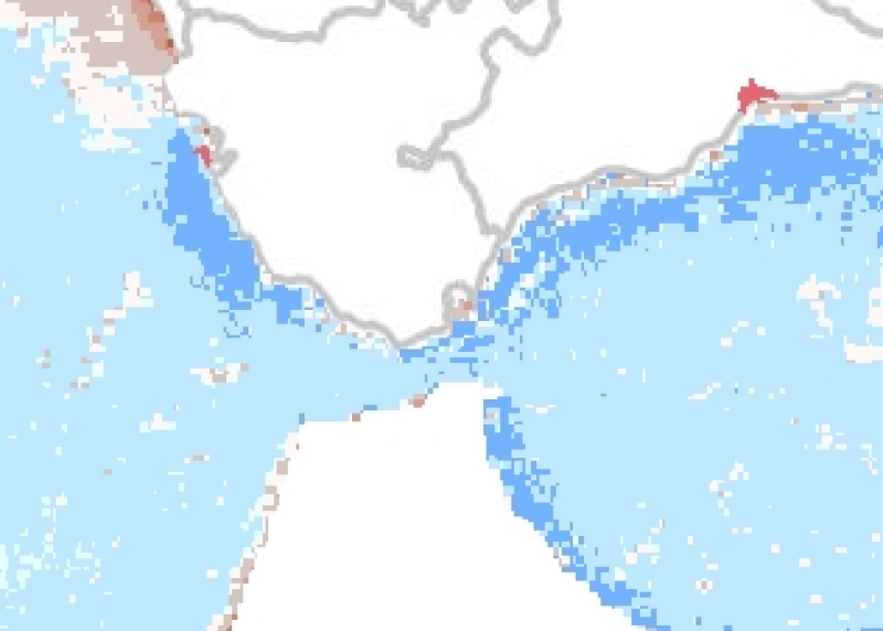
REDIAM. WMS Serie de imágenes de satélite AQUA MODIS. K490 (Transparencia del agua) anomalía anual: Año 2010 respecto a la serie histórica 2000-2010. 1100 m. Océano Atlántico y Mar de Alborán
Nodo de la Red de Información Ambiental de Andalucía. Junta de Andalucía. Imagen de satélite AQUA MODIS anomalía anual de k490 (Transparencia del agua) del año 2010 respecto a la media del periodo 2000-2010. Resolución espacial 1100 m. Ámbito Océano Atlántico y Mar de Alborán. En ETRS89 UTM huso 30. Con el propósito de obtener las anomalías en el comportamiento de k490 (Transparencia del agua) (m-1) en el medio marino correspondiente al último año de estudio, respecto a su comportamiento medio a lo largo de la serie histórica 2000-2010. Con esta imagen, se puede observar el aumento o disminución de este parámetro, que indica cómo es atenuada la luz dentro de la columna de agua, ayudando a caracterizar la transparencia del agua y por tanto estimar el estado de turbidez de las aguas del medio marino. Además, este parámetro tiene muchas aplicaciones en la óptica del océano, como su relación con la concentración de fitoplancton y sedimentos orgánicos e inorgánicos disueltos en el agua marina. Consejería de Medio Ambiente y Ordenación del Territorio. Junta de Andalucía. Nodo de la Red de Información Ambiental de Andalucía. Junta de Andalucía. Integrado en la Infraestructura de Datos Espaciales de Andalucía, siguiendo las directrices del Sistema Cartográfico de Andalucía.
Simple
- Date (Revision)
- 2013-01-17T11:42:44
- Status
- Completed
- Point of contact
-
Organisation name Individual name Electronic mail address Role Consejería de Medio Ambiente y Ordenación del Territorio. Junta de Andalucía
--
Point of contact
- Theme
-
-
WMS
-
Andalucía
-
REDIAM
-
sensor
-
satélite de observación
-
teledetección
-
temperatura
-
Océano Atlántico Norte
-
Océano Atlántico Sur
-
océanos
-
mares
-
humanInteractionService
-
IDEAndalucia
-
- Use limitation
-
Este servicio se puede usar de modo libre y gratuito siempre que se mencione a los autores y propietarios de la información
- Access constraints
- Other restrictions
- Use constraints
- Other restrictions
- Other constraints
-
Creative Commons Reconocimiento 4.0 (CC BY 4.0)
- Service Type
- OGC:WMS
- Service Version
-
1.1.1
- Fees
-
Gratuito
))
- Coupling Type
- Tight
- Contains Operations
- Distribution format
-
Name Version WMS
1.1.1
- OnLine resource
-
Protocol Linkage Name OGC:WMS-1.1.1-http-get-map
http://www.juntadeandalucia.es/medioambiente/mapwms/REDIAM_aquamodis_k490_anual_filtrada_anomal_2000_2010?
- OnLine resource
-
Protocol Linkage Name GLG:KML-2.0-http-get-map
http://www.juntadeandalucia.es/medioambiente/portal_web/rediam/productos/ServiciosOGC/KML/Cartografia_ambiental/Ambitos_interes_ambiental/Indicadores_calidad_agua_litoral/2010_aqua_modis_k490_med_anual_anomal.kml KML servicio
- OnLine resource
-
Protocol Linkage Name WWW:LINK-1.0-http--link
http://www.juntadeandalucia.es/medioambiente/site/rediam/menuitem.04dc44281e5d53cf8ca78ca731525ea0/?vgnextoid=586cb7d7d9ca5310VgnVCM1000001325e50aRCRD&vgnextchannel=08e30b3266be4310VgnVCM2000000624e50aRCRD&vgnextfmt=rediam&lr=lang_es Ficha servicio Canal REDIAM
- Hierarchy level
- Service
Attributes
Conformance result
- Date (Publication)
- 2010-12-08
Citation identifier
- Explanation
-
Consultar el reglamento mencionado
- Pass
- Yes
Metadata
- File identifier
- 032d78cbc5ef77459a020c9986327e3f696af164 XML
- Metadata language
- Spanish; Castilian
- Character set
- UTF8
- Hierarchy level
- Service
- Date stamp
- 2022-09-01T10:34:44
- Metadata standard name
-
ISO 19119/2005
- Metadata standard version
-
1.0
- Metadata author
-
Organisation name Individual name Electronic mail address Role Consejería de Sostenibilidad, Medio Ambiente y Economía Azul. Junta de Andalucía
--
Point of contact
Overviews

Spatial extent
Provided by
